 |
UK Broadcast Transmission |
|
|||||||||||
ITV 405 line VHF TV TRANSMITTERS
NORTH-EAST SCOTLAND
| MOUNTEAGLE | DURRIS | Rumster Forest | Angus | Aviemore | |
| Channel / Polarisation | 12 H | 9 H | 8 V | 11 V | 10 H |
| Max. Vision ERP | 50 kW | 400 kW | 30 kW | 50 kW | 1 kW |
| Site ASL | 695 ft | 1066 ft | 725 ft | 1027 ft | 1360 ft |
| Aerial ASL | 1465 ft | 2016 ft | 1425 ft | 1727 ft | 1505 ft |
| Location (NGR) | NH 640581 | NO 763899 | ND 197385 | NO 395408 | NH 940126 |
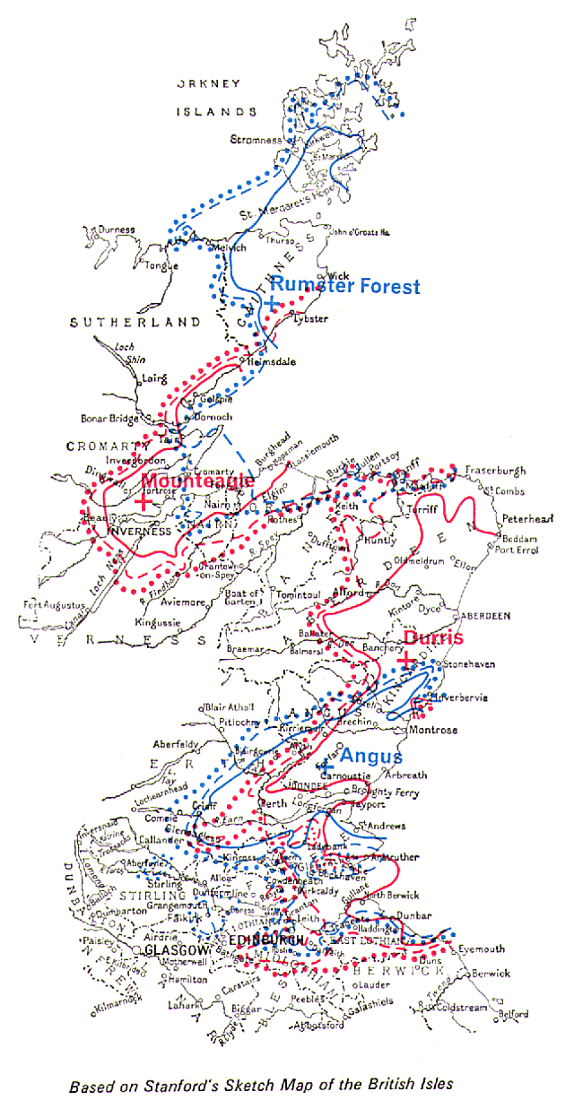
Two stations were opened on 30 September 1961 to cover the most populous parts of North-East Scotland, one of medium power at Mounteagle to serve the Inverness area and another of high power at Durris to cover Aberdeenshire and as much of Angus as possible. For the Inverness area, a site was found at Mounteagle 730 ft above sea level, on the Black Isle, about eight miles north of Inverness and close to the BBC's Band I station at Rosemarkie. An 800 ft mast was used, and the maximum power of 50 kW was radiated in two directions, slightly east of north and east of south respectively. 35 kW was radiated in the direction of Lossiemouth eastwards along the Morayshire coast. Only 10 kW was radiated to the west, over the uninhabited mountainous areas of Ross and Cromarty. Choosing the site for the high-power station to serve Aberdeen/Angus was more difficult because it was decided to try to cover the whole coastal area from Peterhead on the Moray Firth in the north to Arbroath in the south, a distance of some l00 miles, and to include those parts of Dundee which did not receive a satisfactory service from Black Hill. The selected site was at Durris, some 15 miles south of Aberdeen and 1,060 ft above sea level, exposed and difficult of access. A l,000 ft mast was used. Once again this choice involved a departure from the principle of adjacent siting with existing BBC stations. The Durris station beamed its power in two main lobes, each of 400 kW, one directed to the north and the other to the south-west towards Dundee. In 1962 the Authority decided that Independent Television should extend its coverage to Caithness and Orkney and that in the south at Dundee and Perth an improved service should be given in several large residential areas where the signals from Durris and Black Hill were insufficiently strong. A site at Rumster Forest, some 12.5 miles southwest of Wick, was selected as most suitable for the Caithness/ Orkney station. At this site the programmes radiated on Channel 12 by the Mounteagle station could be satisfactorily received 'off-the-air' for rebroadcasting by the new station on Channel 8. With a site height of 725 ft above sea level and a 750 ft mast satisfactory coverage of the desired area has been obtained. Angus, the new station for the Dundee/Perth area, is located at Balcalk Hill, 1,000 ft above sea level. At this site, using a 750 ft mast and directional transmitting aerial, the measured coverage shown on the map above was obtained. This station picked up directly the Channel 9 signals from Durris and re-transmitted them on Channel 11. Both the Rumster Forest and Angus stations are unattended and remotely controlled by their parent stations Mounteagle and Durris respectively. Rumster Forest entered programme service on 25th June 1965 and Angus on 13th October 1965. A small relay station was built to improve reception in the Aviemore area, with a service date of 29 November 1969. |
|
|
|
||||||
|