 |
UK Broadcast Transmission |
|
|||||||||||
THE TRANSMISSION GALLERY
| Photos by Dan Glover (additional information from Martin Brown) | Page last updated: 2023-12-14 |
|
||||||||||||||||||||
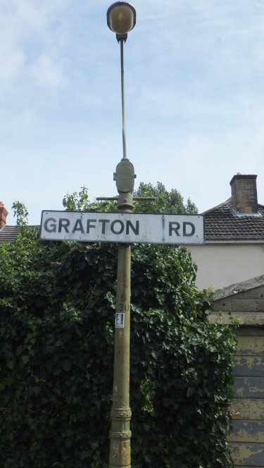
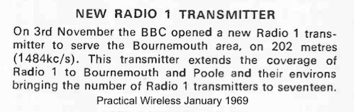
| The page for Fern Barrow (Bournemouth MF) mentions there was at one point a local transmitter for Radio 1 on 202m from a site at Grafton Road in Bournemouth. On first inspection this seems unlikely since Grafton Road is now a residential area, however this was not always the case and the site was used for a number of MF services over the years The recorded NGR for the site is slightly to the east of Grafton Road, however it seems very likely the location was on the opposite side and near to what is now Grafton Close One section of Grafton Road (to the western side and including Grafton Close) was once a council depot, redeveloped in the 1990s. The perimeter wall remains but there is no other obvious trace of the site's previous use Further research shows the depot was, in part at least, the "Borough Incinerator" and a 1940s 1:2500 OS Map shows "Refuse Destructor" with two chimneys marked. Apparently this provided heating for the adjacent (still operational) swimming baths which opened in 1930. The 1924 OS map shows the depot surrounded by fields and only the southern section of what is now Grafton Road only existed to provide access to the depot The Bournemouth "Group H" wartime station is noted as being located at a "refuse destructor" - therefore it seems likely this was the wartime site, subsequently re-used. Possibly a wire antenna supported by the chimneys was used rather than a purpose-built structure? Bournemouth ILR launched from Fern Barrow in September 1980, therefore it is most likely that the BBC radio services transferred to this new site at around the same time. Grafton Road service dates: 23-Mar-1942 Home Service (Group H) on 1474 kHz. Closed 14-Aug-1943. 29-Sep-1946 Third Programme on 1474 kHz. Frequency changed to 1546 kHz from 15-Mar-1950. 3-Nov-1968 Radio 3 frequency changed to 1594 kHz. Transmitter added for Radio 1 on 1484 kHz. 1973, 1594 kHz transferred to Radio Solent. 23-Nov-1978 Transmitter added for Radio 2 on 909 kHz. Radio Solent frequency changed to 1359 kHz. Radio 1 frequency changed to 1485 kHz. 1980 Closed. All services transferred to Fern Barrow. |
| An unusual feature, probably due to the way the area was developed, is the lack of housing on the eastern side of Grafton Road. The pavement runs along the rear boundary of the houses in Fortescue Road with access to garages, etc |

| On the western side, the house on the right is pre-war, that on the left from the 1990s. The old boundary wall for the Grafton Road Depot has been retained on three sides and surrounds Grafton Close |

| Above: 1924 OS Map; below: 1940s version showing the housing development and swimming baths. Images via www.old-maps.co.uk |


| This area behind the houses in Grafton Close corresponds to the "Corporation Yard" on the 1924 map - the houses occupy the site of incinerator building |

| The boundary wall is still in place behind the landscaping - on the other side we can just see the roof of the swimming pool which used heat from the incinerator. July 2014: we've had this further contribution from "a former Bournemouth resident" I lived in Bournemouth during the 1960s and 1970s and was familiar with the Grafton Road transmitter. I can confirm that the transmitter was at or close to the Council refuse site. Tony Blackburn (who spent part of his childhood in Poole, Dorset) often referred to the 202 m transmitter on the air after a 247m jingle with the words "and on 202 metres in the Bournemouth, Poole and surrounding area". Also, when he was DJ at a Radio 1 roadshow at the Pier Approach in 1978 he said the 202 m transmitter was at the Council refuse depot. The mast was a free standing square section tower in two sections: a top half with parallel sides, and a lower half that tapered upwards. I am not sure how it was driven, although I recall the transmitter had two sloping wires attached to the tower, possibly one for each service (Radio 3 then Radio Solent on 188 m, and Radio 1 on 202 m). Rumour has it that Tony Blackburn's grandmother could not hear her grandson on 247 m because reception was so poor, so he arranged for the 202 m relay to be put in that area. The eastern edge of the service area was locally reckoned to be on the A35 road at the "Cat and Fiddle pub" on the flood plain terrace of the River Stour beyond which point the 247m service was usually reckoned to be better. Grafton Road also carried the Radio Solent service on 188 m, after the closure of Radio 3 on that wavelength. Another claim is that the transmitter was put at Grafton Road, because it is close to the highest point in Bournemouth, the oddly-named "Cemetery Junction" a meeting point of several main roads by a cemetery. The arrival of "Two Counties Radio" on 362m/828 kHz required the new transmitter at Fern Barrow. 2CR opened in September 1980 and could be heard as far as Eastbourne, Severn Beach, Torbay and probably the French coast prompting one DJ to say that you could take 2CR on holiday with you. |
History of Stokewood Road Baths
Bournemouth and the Second World War (references to Grafton Road Depot)
Radio 1 relay for Bournemouth
| |
Back to TX Gallery index | TX main index
|